|
Current location: Home > Physical Processes Model > Reach 2 > Primary DriverResidence Time |
|
Reach 2: Primary Driver—Residence Time
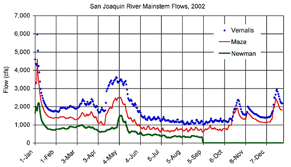
Residence time in Reach 2 is affected by the two secondary drivers shown above. Click on a secondary driver to jump down to the discussion of that driver. See the Basic Concepts page for a general discussion of how the secondary drivers affect the primary driver. Flow in Reach 2 is primarily governed by the timing and volume of inflows from Reach 1 (i.e., Vernalis). There are only minor local inflows in this reach, including discharge from French Camp Slough and agricultural return flows pumped over the levees. Agricultural return flows have not been measured in this reach but have been estimated at less than 10% of the total river flow at 1,000 cfs (Quinn and Tulloch 2002). Discharges from the Stockton RWCF also contribute flows of about 50 cfs to the downstream end of Reach 2 (Quinn and Tulloch 2002;Lee and Jones-Lee 2000 and 2003; Lehman et al. 2004; Lee 2004). The Banta-Corbona diversion canal pumps about 125 cfs during the summer from a relatively new (2002) fish screen facility about 5 miles downstream of Vernalis. Relatively minor diversions occur at smaller agricultural pump locations in Reach 2, but the major diversion occurs at the Old River channel bifurcation (Chen and Tsai 2002; Foe and McCarthy 2002). The natural flow split at the head of Old River, located 5 miles downstream of Mossdale, is about 50% into Old River. However, as State and Federal pumping increases, a greater fraction of the water is diverted into Old River. Operation of the south Delta in-channel temporary barriers has increased Reach 2 flows and may have increased DO concentrations in late summer and fall (Ralston and Hayes 2002; Lee and Jones-Lee 2000). The Old River diversion has the greatest impact on San Joaquin River flows during the summer and early fall before the Head of Old River barrier is installed in the fall to increase San Joaquin River flows at Stockton for fish (Jones & Stokes 2002a). Flows in Reach 2 at Stockton have been measured since 1996 at a USGS tidal flow station. The figure below shows the daily average flows for 2002. The tidal flows add an upstream (negative) flow of about 2,000 cfs during flood tide, and the downstream flow is increased by about 2,000 cfs on ebb tides.
The Old River diversion can be approximated by:
Only when pumping is about 10 times the Vernalis flow will the entire San Joaquin River flow be diverted into Old River. Periods of reverse flow in the lower end of Reach 2 are possible but have not been observed since 1996. Travel times from Vernalis to Mossdale have been calculated with the DSM2 hydraulic model for a range of flows. The travel times between Mossdale and Channel Point (approximately 15 miles apart) are generally between 1 and 2 days at San Joaquin River flows greater than approximately 750 cfs (Lee and Jones-Lee 2003). Table 1 shows the total travel time for Reach 2, for a range of flows between 750 cfs and 7,000 cfs. The travel time is 64 hours when the flow is 750 cfs (with no diversions) and is reduced to just 12 hours at a flow of 7,000 cfs. The river portion between Vernalis and Mossdale is 24 hours at a flow of 750 cfs, and just 8 hours at a flow of 7,000 cfs. The volume between Mossdale and Channel Point is about 2,500 acre-feet, so the travel time is inversely related to the flow. Reach 2 flows are affected by flow received from Reach 1, local inflows, diversions, operation of the south Delta barriers, and pumping at State Water Project and Central Valley Project pumps (Lee and Jones-Lee 2003, 2001, and 2000; Quinn and Tulloch 2002; Ralston and Hayes 2002; Foe and McCarthy 2002). The available information suggests that flow is an important factor affecting residence time in Reach 2. Jump to "Residence Time > Secondary Driver—Flow" under:
Reach 1 |
Reach 3 Secondary Driver—Channel Geometry The geometry of the San Joaquin River channel in Reach 2 affects residence time by affecting flow velocity. The river has a natural channel shape in this reach, ranging in width from about 150 feet at the Head of Old River to about 250 feet where it transitions to the DWSC. The channel along this reach is relatively shallow and averages about 8 feet in depth. ( Jones & Stokes 2002c; California Regional Water Quality Control Board, Central Valley Region 2004). Table 1 shows some of the channel geometry parameters for a range of flows between 750 and 7,000 cfs. The riverine portion above Mossdale is separately calculated with the DSM2 hydraulic model. The geometry between Mossdale and Channel Point is assumed to be nearly constant (tidal) for this range of flows. The water surface is elevated, and the total volume is increased at higher flows. The San Joaquin River channel in Reach 2 is confined by existing State and Federal project levees but is otherwise unmanaged. The channel geometry is therefore affected by natural riverine processes occurring in the constraints of a leveed system. The available information suggests that channel geometry is an important factor affecting residence time in Reach 2. Jump to "Residence Time > Secondary Driver—Channel Geometry" under:
Reach 1 |
Reach 3 Uncertainties in Residence Time Uncertainties related to understanding how residence time in Reach 2 may affect low DO concentrations in the DWSC include the need for a better description of the decay and settling processes in the tidal reach between Mossdale and Channel Point. This uncertainty is one of the major topics (i.e., linkage between riverine habitat and tidal DWSC habitat) being investigated in the "Upstream Studies" during 2005–2007. Jump to "Residence Time > Uncertainties in Residence Time" under:
Reach 1 |
Reach 3 |