|
San Joaquin River Water Quality Data Atlas
The San Joaquin River Water Quality Data Atlas (Data Atlas) was created to give stakeholders, agencies, and other interested persons a rapid and consistent method to access all available data on the San Joaquin River and DWSC flow and water quality conditions for the 20-year period of 1984 to 2003 (now extended to 2005). The Data Atlas includes flow and water quality data from the San Joaquin River Stevinson gage downstream to the DWSC. Tributary flow and water quality data are included for the Merced, Tuolumne, and Stanislaus Rivers, as well as Salt Slough and Mud Slough.
The Data Atlas uses a spreadsheet format that enables you to easily display daily flow and water quality data by simply entering the year of interest.
While the Data Atlas contains many files, at present, direct access from this site is provided to the Data Atlas report and six spreadsheets. Right-click on the links below to download the files.
File to Download |
Description |
San Joaquin River Data Atlas Report, January 2005
(6.3 Mb PDF) |
Report describing how to use the Data Atlas. |
Meteorology for 19842005
(2.8 Mb ZIP) |
Excel spreadsheet containing graphs of the daily meteorology for the CIMIS stations at Lodi, Modesto, and Kesterson. |
San Joaquin River Electrical Conductivity and Flow 19842005
(2.6 Mb ZIP) |
Excel spreadsheet containing graphs to compare salinity (as electrical conductivity) and flow variations and relationships along the San Joaquin River. |
Stockton River Water Quality for 19842005
(1.0 Mb ZIP) |
Excel spreadsheet containing the water quality measurements that have been made by the City of Stockton for its National Pollutant Discharge Elimination System permit. |
Stockton RWCF 19842005
(460 kb ZIP) |
Excel spreadsheet containing the daily discharge and water quality measurements of final effluent from the Stockton RWCF. |
DWSC DO 19842005
(588 kb ZIP) |
Excel spreadsheet containing the daily minimum, average, and maximum daily DO data from Mossdale and Rough and Ready Island monitoring station. |
Nutrients and Algae 19842005
(5.9 Mb ZIP) |
Excel spreadsheet containing the data collected by Randy Dahlgren at U.C. Davis on nutrients, particulates, and algae pigments. |
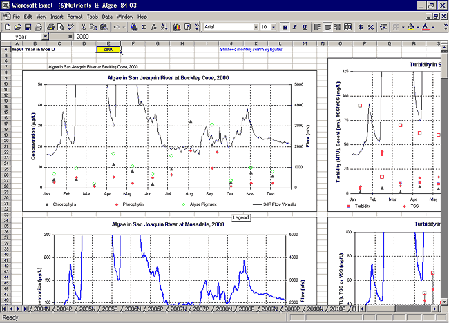
The screenshot below shows an example of how data are retrieved and presented in the Data Atlas.
|