|
Current location: Home > Physical Processes Model > Reach 3 > Primary Driver—Reaeration |
|
Reach 3: Primary Driver—Reaeration
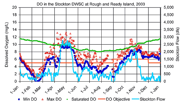
Reaeration in Reach 3 (i.e., the DWSC) is affected by the three secondary drivers shown above. Click on a secondary driver to jump down to the discussion of that driver. See the Basic Concepts page for a general discussion of how the secondary drivers affect the primary driver. Factors affecting wind are, for the most part, not reach specific and are therefore described only in the general discussion on the Basic Concepts page. Seasonal DO concentrations in Reach 3 (i.e., the DWSC) are shown in the figure below. Reaeration cannot be measured directly but is assumed to be a major factor in Reach 3 because the DO concentration is maintained near saturation levels for most of the year. However, because the DO concentration is considerably below the saturation level during the summer, reaeration must be less than the DO depletion from BOD and SOD in the DWSC.
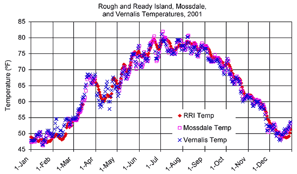
Secondary Driver—Water Temperature Water temperature is a primary factor controlling reaeration rates because the amount of oxygen that can be dissolved in water is proportional to water temperature. The saturated DO is about 12 mg/L in the winter and 8 mg/L in the summer. The water temperature conditions in Reach 3 are described below. As shown in the figure below, water temperatures in Reach 3 (Rough and Ready Island) are generally very similar to temperatures in Reaches 1 (Vernalis) and 2 (Mossdale). Water temperatures in the upstream portions of Reach 3 (i.e., near Channel Point) are slightly higher than temperatures in the downstream portion of the reach (i.e., near Disappointment Slough) (Lehman and Ralston 2001). Near surface water temperatures in the DWSC are slightly higher (0.51ºC) than temperatures near the bottom during the day in July and August (Jones & Stokes 2001a). However, the DWSC is generally well mixed at night, and substantial temperature stratification typically does not occur (Jones & Stokes 2002a; Jones & Stokes 2001a).
Seasonally, water temperatures in the DWSC are generally greater than 77°F (25°C) in the summer and less than 50°F (10°C) during the winter (Lehman and Ralston 2001). Surface water temperatures in the Turning Basin are slightly higher than temperatures in the DWSC ( Lehman 2003). In addition, Turning Basin water temperatures are generally more stratified (2°C difference between surface and bottom temperatures) than in the DWSC (Lehman 2003). Jump to "Reaeration > Secondary Driver—Water Temperature" under:
Reach 1 |
Reach 2 Secondary Driver—Flow Velocity Higher flow velocities generally produce greater reaeration rates in rivers. However, in the DWSC, tidal flows dominate and water velocities do not change with net river flow. Wind speed may have a relatively larger effect on reaeration rate in the DWSC. Jump to "Reaeration > Secondary Driver—Flow Velocity" under:
Reach 1 |
Reach 2 Secondary Driver—Channel Geometry The geometry of the DWSC affects reaeration rates because the greater channel depth reduces the amount of oxygen that can be transferred from the water surface to the total volume of water, and thereby reduces the natural atmospheric reaeration efficiency (Foe et al. 2002). As indicated in Table 1, the average and maximum depths in the DWSC, from Channel Point to Turner Cut, are 22 and 35 feet, respectively. The DWSC depths are substantially greater than the maximum depths (710 feet) in Reaches 1 and 2 during low flows of 750 cfs and maximum depths (1516 feet) at higher flows of 7,000 cfs. The surface area of the DWSC is 850 acres and does not vary with flow (Table 1). Jump to "Reaeration > Secondary Driver—Channel Geometry" under:
Reach 1 |
Reach 2 Reaeration cannot be measured directly and must be inferred from DO depletion within the DWSC. Uncertainties in the reaeration rate (i.e., grams DO/acre/day) within the DWSC are quite large. Uncertainties related to understanding how reaeration may affect DO concentrations in the DWSC include effects of:
Jump to "Reaeration > Uncertainties in Reaeration" under:
Reach 1 |
Reach 2 |